
Weekly Highlights
 Dominica+(tied with
  Grenada)42°C107°F Aug 30Hottest Grenada+(tied with STT
 Saint Thomas)34°C93°F Aug 25Coolest
 Antigua and Barbuda+(tied with
  British Virgin Islands)23°C74°F Aug 30Windiest
 Anguilla44 km/h27 mph Aug 30Wettest Dominica52.3 mm2.06 in (heaviest day Aug 29: 10.5 mm0.41 in)DriestSTT Saint Thomas13.1 mm0.52 in
Based on data collected across 18 Eastern Caribbean islands over the past 7 days.
Regional Conditions This Past Week
The Eastern Caribbean experienced warm, humid conditions over the past seven days typical of peak hurricane season, with temperatures ranging from 23°C72°F to 34°C93°F. Dominica recorded the most oppressive conditions, with feels-like temperatures reaching 42°C107°F, while Antigua and Barbuda posted the coolest lows at 23°C72°F. Humidity averaged 86 percent across the region, and scattered to broken cloud cover dominated the skies.
Dominica saw the heaviest rainfall last week with 52.3 mm2.06 in, while Saint Thomas remained driest at 13.1 mm0.5 in. Elevated Saharan dust affected air quality throughout the week, with peak concentrations reaching 41 µg/m³ over Barbados.
This Week's Outlook
Moisture and atmospheric instability associated with the remnants of Tropical Storm Dolly will keep the Eastern Caribbean unsettled through Monday. Cloudy to overcast skies with periods of moderate to heavy showers and widespread thunderstorms are expected, accompanied by strong, gusty southeast winds. Sea conditions will run moderate, with waves between 1.8 to 3.1 metres6 to 10 feet.
Peak winds reached 44 km/h27 mph at Anguilla during the week and similar gusts are likely to continue. Beyond Monday, conditions should begin to stabilize as the tropical wave moves west-northwestward into the central Caribbean, though typical trade winds and moderate seas will persist across the region for the remainder of the week. Average surface pressure held steady at 1015 mb.
Tropical Activity
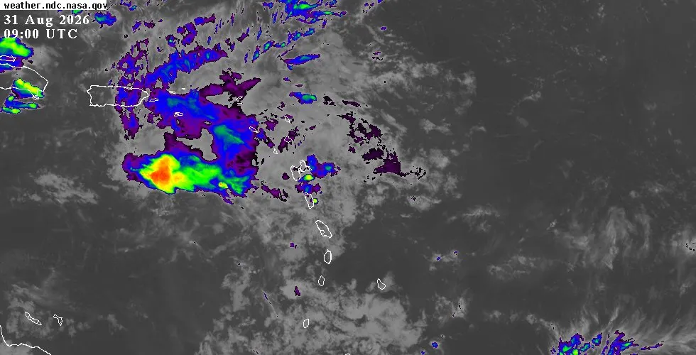
A tropical wave identified as the remnants of Tropical Storm Dolly moved through the Eastern Caribbean over the weekend and into Monday morning. The system crossed near Saba on Saturday, August 30, at a distance of just 55 km34 mi, and continued to produce showers and thunderstorms across the Leeward Islands, British Virgin Islands, and Puerto Rico. The National Hurricane Center reported no signs of a closed surface circulation, and redevelopment remains unlikely as the wave moves west-northwestward at approximately 20 knots.
Locally heavy rainfall and gusty winds are the primary hazards through Monday across the northern Caribbean islands. The system has a low chance of tropical cyclone formation as it progresses into the western Caribbean.
Looking Ahead
Residents and visitors throughout the Eastern Caribbean should monitor conditions closely through Monday, particularly in the Leeward Islands and the Virgin Islands where the heaviest rain and strongest winds are most likely. Flash flooding is possible in areas of steep terrain. For detailed, island-by-island conditions and hourly updates, visit the weather page.
The full outlook page features the latest National Hurricane Center tropical weather outlook, satellite imagery, and extended forecasts. Live radar and satellite imagery by location is available on the interactive map.