
GOES-16 IR Caribbean. Image courtesy of NOAA. Updated: 2026-07-15 2:30 PM AST. 13 min ago
Eastern Caribbean Forecast
Updated: 2026-07-15 02:15 AST 12 hours ago
A surface to mid-level ridge pattern will remain dominant and no significant shower activity is expected across the area. Another tropical wave will be approaching the region overnight.
Winds: Easterly at 9 to 30 km/h or 6 to 18 mph.
Seas: 1 to 1.8 metres or 3 to 6 feet.
Forecaster: Patrice Edwards — A daily forecast issued by the Antigua & Barbuda Met Office, covering the Eastern Caribbean islands.
NHC Eastern Caribbean Outlook
Updated: 2026-07-15 12:55 PM AST 1 hr ago
An eastern Atlantic tropical wave is along 26.5W, south of 18N, moving westward at 15 kt. Scattered moderate to isolated strong convection is noted from 02.5N to 10N between 24W and 29W.
A new tropical wave has moved off the coast of West Africa; the wave axis is along 17.5W and south of 16N. Ahead of this wave, a weak 1014 mb low pressure has formed along the monsoon trough. Numerous moderate convection is depicted from 06N to 13N and east of 24W.
From the NHC Tropical Weather Discussion, issued four times a day, showing weather and systems relevant to the Eastern Caribbean.
— Forecaster: KRV
")

Image courtesy of NOAA. Updated at approximately 2 AM, 8 AM, 2 PM, and 8 PM EDT from 15 May to 30 November, with special outlooks issued at any time as conditions warrant. The graphic displays all currently active tropical cyclones, and disturbances with tropical cyclone formation potential over the next five days.
Updated: 2026-07-15 2:00 PM AST 43 min ago
Eastern Tropical Atlantic: Showers and thunderstorms associated with a tropical wave southeast of the Cabo Verde Islands have become a little better organized during the past 24 hours. Some additional slow development is possible over the next couple of days as the system moves generally west-northwestward. After that, the system is expected to move into an environment that is not conducive for additional development by the weekend.
* Formation chance through 48 hours...low...10 percent.
* Formation chance through 7 days...low...10 percent.
Atlantic storm names for 2026
- Arthur AR-thur
- Bertha BUR-thuh
- Cristobal krees-TOH-bahl
- Dolly DAH-lee
- Edouard eh-DWARD
- Fay fay
- Gonzalo gohn-SAH-loh
- Hanna HAN-uh
- Isaias ees-ah-EE-ahs
- Josephine JOH-seh-feen
- Kyle KY-ull
- Leah LEE-ah
- Marco MAR-koe
- Nana NA-na
- Omar OH-mar
- Paulette pawl-LET
- Rene re-NAY
- Sally SAL-ee
- Teddy TEHD-ee
- Vicky VIH-kee
- Wilfred WILL-fred
Regional Satellite Animations
Updated: 2026-07-15 2:35 PM AST 7 min ago
These satellite animations cover the Eastern Caribbean and the full tropical Atlantic from the West African coast to the Caribbean Sea. Each animation starts as a still image. Click play to start.
GOES East Infrared – Caribbean
An enhanced infrared satellite animation from GOES East (Band 13, 10.3 µm) focused on the Eastern Caribbean. Infrared imagery detects heat radiating from cloud tops — the colder (and therefore higher) a cloud top, the more likely it is producing heavy rain or thunderstorms. Bright blue-green and white areas indicate very cold, tall cloud tops associated with active convection, while grey tones show lower, warmer clouds or clear skies. This view is particularly useful at night when visible imagery is unavailable, and for spotting developing thunderstorm clusters that could organise into tropical disturbances.

Satellite animation courtesy of NASA/MSFC.
GOES East Infrared – Atlantic
A wider infrared satellite animation from GOES East (Band 13, 10.3 µm) covering the tropical Atlantic from the Eastern Caribbean to the West African coast. This zoomed-in view makes it easier to track individual cloud clusters and tropical waves as they cross the Atlantic — the classic path toward the Caribbean during hurricane season. The colour scale highlights cold, high cloud tops in blue-green and white (indicating deep convection and potential storm development), while warmer grey tones represent lower clouds or clear skies.

Satellite animation courtesy of NASA/MSFC.
GOES‑19 Caribbean – Geocolor
GeoColor imagery shows the Earth as it appears to the human eye during the day, with enhanced city lights and infrared cloud detection at night. This close-up view of the Caribbean basin highlights cloud formations, approaching weather systems, and the Saharan dust layer (visible as a hazy brownish tint over open water). Useful for seeing the overall state of weather around the Eastern Caribbean islands at a glance.

Satellite animation courtesy of NOAA.
GOES‑19 Tropical Atlantic – Geocolor
GeoColor imagery shows the Earth as it appears to the human eye during the day, with enhanced city lights and infrared cloud detection at night. This wide-angle view stretches from the West African coast to the Caribbean, making it ideal for tracking tropical waves as they move westward across the Atlantic — the classic path that can lead to tropical storm and hurricane development during the season. You can also observe large-scale cloud patterns, the Saharan dust layer (appears as a hazy brownish tint), and the overall state of the tropical Atlantic.

Satellite animation courtesy of NOAA.
The two "visible band" animations below only include frames captured during daylight hours. Nighttime frames appear dark and are excluded.
GOES East Visible – Leeward Islands
A high-resolution visible satellite animation from GOES East (Band 2, 0.64 µm) centred on the Leeward Islands. Visible imagery shows clouds as the human eye would see them from space — bright white areas are thick clouds likely producing showers, while thin wispy clouds appear grey. This band offers the sharpest detail of any GOES channel, making it excellent for tracking individual shower cells, sea breeze boundaries, and developing convective systems. Visible imagery is only available during daytime hours.

Satellite animation courtesy of NASA SPoRT/MSFC.
GOES East Visible – Windward Islands
A high-resolution visible satellite animation from GOES East (Band 2, 0.64 µm) centred on the Windward Islands. Same technology as above but framed to show the southern Eastern Caribbean, useful for monitoring approaching weather from the south and east, including interaction of tropical waves with the ITCZ (Inter-Tropical Convergence Zone). Only available during daytime.

Satellite animation courtesy of NASA SPoRT/MSFC.
Wind & Forecasts
Updated: 2026-07-15 1:50 PM AST 53 min ago
The surface chart forecasts 24 hours ahead; the wind and wave charts cover the next 12 hours. Updated several times daily.
Winds are light to breezy across the Eastern Caribbean.
Readings updated: 2026-07-15 2:00 PM AST 43 min ago
- Barbados 32 km/h20 mph
- Martinique 30 km/h18 mph
- Grenada 28 km/h18 mph
- Saba 27 km/h17 mph
- Anguilla 26 km/h16 mph
- St Vincent 26 km/h16 mph
- Saint Barthélemy 25 km/h16 mph
- Guadeloupe 24 km/h15 mph
- British Virgin Islands 24 km/h15 mph
- Saint Martin 23 km/h14 mph
- Saint Thomas 23 km/h14 mph
- Dominica 22 km/h14 mph
- Montserrat 22 km/h14 mph
- Saint Kitts and Nevis 20 km/h13 mph
- Saint Lucia 20 km/h13 mph
- Saint Croix 20 km/h13 mph
- Sint Eustatius 20 km/h13 mph
- Antigua and Barbuda 19 km/h11 mph
Light to breezy (under 29 mph) Very breezy (29–33) Windy (34–38) Tropical storm (39–73) Hurricane (74+)
12-hour wind forecast
Shows predicted wind speeds across the Caribbean basin for the next 12 hours. The colour-filled regions use a rainbow scale — purple and blue shades represent lighter winds, greens and yellows indicate moderate winds, and orange to red areas signal the strongest winds. The colour bar along the top of the chart shows the wind speed values in knots. Use this chart to anticipate incoming wind changes, assess conditions for maritime travel, or gauge how a developing weather system may affect wind patterns in your area.

Image courtesy of NOAA.
Tropical Atlantic 12-hour wave height forecast
GFS-Wave significant wave height in metres (colour scale on the left) with 10-metre wind barbs, 12 hours from the issue time, across the tropical Atlantic from the Eastern Caribbean toward the West African coast. Cooler blues are calmer seas; greens, yellows and reds mark progressively higher waves. Useful for boating, fishing and coastal activities, and for tracking swells from distant storms. Click the image to enlarge it.

Image courtesy of NOAA.
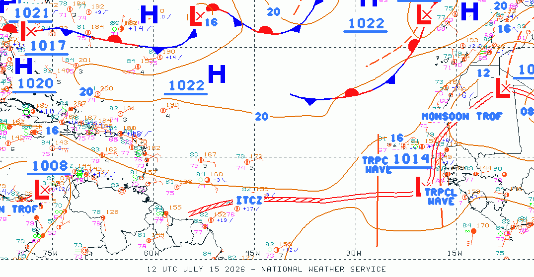
Tropical Atlantic 24-hour surface forecast
The forecast position of pressure systems (highs and lows), fronts, troughs, tropical waves (dashed lines tracking westward, often the seeds of tropical storms in season), the monsoon trough and the ITCZ, 24 hours from the issue time. Tightly packed isobars mean stronger winds. Click the image to enlarge it for easier reading.

Image courtesy of NOAA.
Rainfall Tracking
Satellite updated: 2026-07-15 8:00 AM AST 6 hours ago
Rainfall over the last 24 hours. Plus, 3-hour and 24-hour satellite precipitation maps.
Light rain across parts of the region, heaviest over Dominica, Antigua and Barbuda, and Martinique.
Readings updated: 2026-07-15 2:00 PM AST 43 min ago
- Dominica Light 1.6 mm0.06 in
- Antigua and Barbuda Light 1.4 mm0.06 in
- Martinique Light 1.2 mm0.05 in
- Saint Kitts and Nevis Light 0.4 mm0.02 in
- Saint Lucia Light 0.2 mm0.01 in
- Guadeloupe Light 0.2 mm0.01 in
- Grenada Light 0.1 mm0.00 in
- Anguilla Light 0.1 mm0.00 in
- Barbados Light 0.1 mm0.00 in
- Saint Martin Light 0.1 mm0.00 in
- Saint Croix Light 0.1 mm0.00 in
- Montserrat Dry 0.0 mm0.00 in
- St Vincent Dry 0.0 mm0.00 in
- British Virgin Islands Dry 0.0 mm0.00 in
- Saint Thomas Dry 0.0 mm0.00 in
- Saba Dry 0.0 mm0.00 in
- Saint Barthélemy Dry 0.0 mm0.00 in
- Sint Eustatius N/A no local data
Light under 25 mm, moderate 25–50, heavy 50–100, very heavy 100–200, flood 200+ mm.Light under 1 in, moderate 1–2, heavy 2–4, very heavy 4–8, flood 8+ in.
Satellite-derived rainfall for the Eastern Caribbean from NASA IMERG Early. Each map below opens as a still image showing the most recent total. Press play to step back through its history:
- 3-Hour Rainfall Totals: the still shows the latest 3-hour total. Press play to review the last 48 hours in 3-hour steps and watch the rain bands move across the islands.
- 24-Hour Rainfall Totals: the still shows the latest full-day total. Press play to review the last 7 days, one day at a time.
3-Hour Rainfall Totals (early) – Caribbean
3-hour rainfall totals from NASA IMERG Early, which runs about 4 hours behind real time — so this is the most recent view. Each frame is a 3-hour window covering the last 48 hours; press play to watch the rain bands move across the islands. Greens are lighter totals; yellow, orange and red mark progressively heavier rainfall (see the inch scale on the image).

Animation courtesy of NASA SPoRT.
24-Hour Rainfall Totals (early) – Caribbean
24-hour rainfall totals from NASA IMERG Early. Each frame is a full day; press play to step through the past week, one day at a time, for a longer-range picture of where the heaviest rain fell. Blues and greens are lighter totals; yellow, orange and red mark progressively heavier accumulations (see the inch scale on the image).

Animation courtesy of NASA SPoRT.
Saharan Dust
Updated: 2026-07-15 2:40 PM AST 3 min ago
Dust is currently low across the Eastern Caribbean.
Readings updated: 2026-07-15 2:00 PM AST 42 min ago
- Saint Barthélemy Low AOD 0.38
- Anguilla Low AOD 0.36
- Saint Martin Low AOD 0.36
- Sint Eustatius Low AOD 0.36
- Saba Low AOD 0.36
- Saint Kitts and Nevis Low AOD 0.32
- Saint Croix Low AOD 0.31
- British Virgin Islands Low AOD 0.29
- Saint Thomas Low AOD 0.29
- Montserrat Low AOD 0.22
- Antigua and Barbuda Low AOD 0.21
- Grenada Low AOD 0.21
- Barbados Low AOD 0.17
- St Vincent Low AOD 0.16
- Dominica Low AOD 0.13
- Guadeloupe Low AOD 0.13
- Martinique Low AOD 0.13
- Saint Lucia Low AOD 0.12
Aerosol optical depth (AOD): how much dust and haze fills the air column. Low under 0.4, elevated 0.4–0.69, high 0.7–1.19, very high 1.2–1.99, extreme 2.0+.
GOES RGB Caribbean – Dust
This specialised RGB (Red-Green-Blue) composite highlights Saharan dust plumes travelling westward across the Atlantic into the Caribbean. Dust typically appears as bright pink or magenta areas, while clouds show as darker red or brown tones and clear sky appears as a deep blue-black. Saharan dust affects the Caribbean in two important ways: it degrades air quality, aggravating respiratory conditions such as asthma and allergies, and it suppresses tropical cyclone development by introducing dry, stable air and increasing wind shear that disrupts storm organisation. During hurricane season, heavy dust outbreaks often coincide with quieter tropical activity, so tracking dust movement can help indicate when conditions are less favourable for storm formation. The image can also reveal other atmospheric features such as volcanic aerosols and wildfire smoke.

Image courtesy of NOAA.
The Natural Color image below uses visible light and is most useful during daylight hours. At night, the last daytime image is shown.
Saharan Air Layer – Natural Color
A natural-colour satellite view of the tropical Atlantic highlighting the Saharan Air Layer. Dust appears as a hazy tan or brownish plume stretching westward from the African coast across the ocean. Unlike the specialised RGB composite above, this image shows the atmosphere roughly as the human eye would see it from space, making it intuitive for spotting large-scale dust outbreaks. Dense dust reduces visibility and gives the sky a milky appearance over affected areas.

Image courtesy of UW-CIMSS/SSEC and NOAA.
Sea Temperatures
Updated: 2026-07-15 2:40 PM AST 2 min ago
Sea surface temperatures (SSTs) are a key factor in tropical cyclone development — waters above 26.5 °C (79.7 °F) provide the heat energy that fuels storms, with waters reaching 29–30 °C (84–86 °F) creating conditions where hurricanes can rapidly intensify. The 7-day composite shows the latest SST analysis for the Atlantic Main Development Region, while the 30-day animation reveals how temperatures have been trending across the Caribbean.
Sea Surface Temps – 7-day Composite
Sea surface temperature (SST) analysis for the Atlantic Main Development Region, where the majority of Cape Verde-type hurricanes form and intensify. Waters warmer than 26.5 °C (79.7 °F) provide the energy needed to sustain tropical cyclones. The warmer and deeper the warm water pool, the greater the potential for rapid intensification. During hurricane season, this image helps identify pockets of anomalously warm water that could fuel approaching tropical disturbances.

Image courtesy of NASA SPoRT.
Sea Surface Temps – Last 30 days
Shows how ocean surface temperatures have changed across the Caribbean over the past 30 days. During hurricane season, watch for unusually warm patches (deep reds and oranges), which can signal areas where approaching storms may strengthen significantly. Outside of hurricane season, SST trends help indicate the onset of warmer waters and the transition into the active period.

Animation courtesy of NOAA.
Information on this page is updated according to the National Hurricane Center’s bulletin schedule. Satellite imagery refreshes approximately every 10 minutes.
The Eastern Caribbean Forecast is updated at least daily, year‑round, and more frequently whenever new discussions are issued.
The Tropical Weather Outlook section follows the NHC’s scheduled outlooks (four times daily from May 15 to November 30) and is hidden during the off‑season unless the NHC issues a special outlook.