

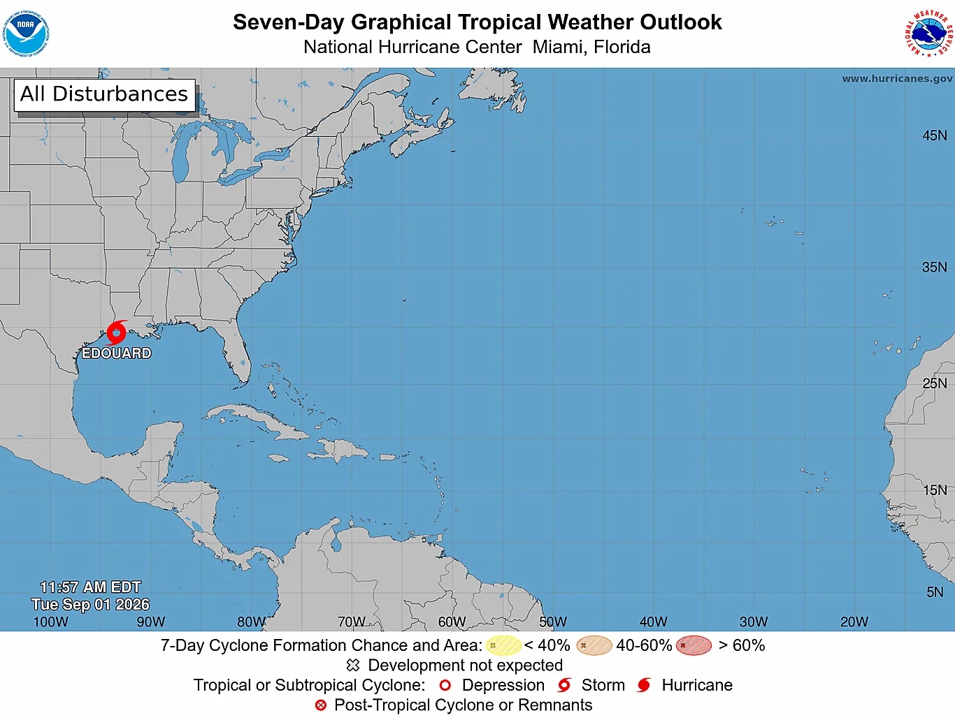
September marks the peak of Atlantic hurricane season, and the 2026 outlook remains one of well-below-normal activity across the basin. As of the start of the month, only five named storms have formed so far this year, compared to a climatological average of 14 by this time. Tropical Storm Edouard is currently active in the northwestern Gulf of America, but poses no direct threat to the Eastern Caribbean islands.
The coming weeks will be shaped by strong El Niño conditions and elevated wind shear, both of which suppress hurricane development across the Atlantic and Caribbean.
Season Snapshot
Atlantic season runs June 1 to November 30. Storm counts for 2026 from the Dewedda.com tracking database; season averages from NOAA 1991-2020 climatology. Track activity live on the interactive map.
Season-to-Date: Well Behind Average
Through the end of August, the 2026 Atlantic hurricane season has produced five named storms, zero hurricanes, and zero major hurricanes. This is significantly below the NOAA 1991-2020 climatological average of 14 named storms, 7 hurricanes, and 3 major hurricanes by early September. The season's slow start aligns with seasonal forecasts issued in spring and updated through August, all of which called for well-below-normal activity.
The next storm names available are Fay, Gonzalo, and Hanna. Historically, September 10 marks the climatological peak of Atlantic hurricane season, meaning the remainder of the month is typically when the basin sees its highest frequency of tropical development.
Current Atlantic Basin Conditions
Tropical Storm Edouard is the only active cyclone in the Atlantic basin as of September 1, located over the northwestern Gulf of America near 29.4°N 93.3°W29.4°N 93.3°W. The system carries winds of 85 km/h50 mph and is moving west-northwestward toward the Louisiana-Texas coast. This system is well removed from the Caribbean and poses no threat to the Eastern Caribbean islands.
The broader Atlantic environment remains highly suppressive to tropical development. El Niño conditions continue to strengthen in the tropical Pacific, and these conditions are expected to intensify through September. According to Colorado State University's August forecast, El Niño is the dominant factor driving very high levels of tropical Atlantic vertical wind shear, which tears apart developing systems before they can organize.
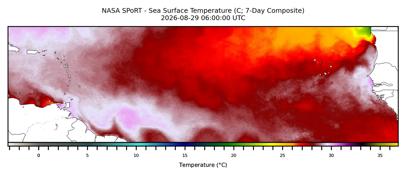
Sea surface temperatures across the Caribbean and tropical Atlantic remain slightly above long-term averages, but the wind shear environment overwhelms this marginal warmth. The National Hurricane Center's 7-day outlook explicitly states that tropical cyclone formation is not expected during the next 7 days across the Atlantic basin.
Multiple tropical waves are being monitored across the eastern and central Atlantic. An eastern Atlantic tropical wave is located at 31°W31°W south of 20°N20°N, with scattered moderate convection between 05°N and 14°N05°N and 14°N. A central Atlantic tropical wave is near 49°W49°W south of 23°N23°N.
A western Caribbean tropical wave is near 83°W83°W south of 17°N17°N. While these disturbances are being tracked, the hostile atmospheric conditions make significant development unlikely in the near term.
What Forecasters Expect for September
NOAA's Climate Prediction Center predicts 7 to 13 named storms for the full 2026 season, with 2 to 6 becoming hurricanes and 0 to 2 becoming major hurricanes. This is well below the long-term average. Colorado State University's August forecast predicts a total of 9 named storms, 4 hurricanes, 1 major hurricane, and accumulated cyclone energy of 50 units for the entire season, all substantially below normal.
CSU forecasters note with high confidence that strong El Niño will dominate the season and drive above-normal wind shear, suppressing tropical activity. The forecast explicitly notes a well-below-average probability for major hurricane landfalls in the Caribbean and along the continental United States.
What This Means for the Eastern Caribbean
The Eastern Caribbean islands have benefited from the same suppressive conditions that have defined the 2026 season so far. The latest offshore waters forecasts for the Leeward Islands, Windward Islands, and northeastern Atlantic waters show typical trade wind conditions with easterly winds of 19 to 28 km/h12 to 17 mph and seas ranging from 0.9 to 1.8 m3 to 6 ft through early September. Scattered showers and isolated thunderstorms are noted in some zones, but no organized tropical systems threaten the islands.
The outlook for September maintains this benign pattern, though vigilance remains essential.
What Residents and Travelers Should Do Now
Below-normal seasonal activity does not mean zero risk. One strong hurricane is enough to cause significant damage, and the islands' exposure to tropical systems does not disappear simply because the season is expected to be quiet. All residents, businesses, and visitors should maintain standard hurricane preparedness year-round: secure supplies, know evacuation routes, maintain insurance, and monitor official forecasts regularly.
Monitor the tracking map and forecast outlook on Dewedda.com for any development. While September is progressing quietly so far, the month is just beginning, and October remains on the calendar. Stay prepared and stay informed.